Urban drone flights over Kosovo offer rare insights
To support safe drone deliveries and “air taxi” flights over cities, Embry-Riddle researchers recently leveraged a small unmanned aerial system (sUAS) to map atmospheric conditions close to the Earth’s surface – a project believed to be the first of its kind.
The study, offering a rare opportunity to fly drones through “urban canyons” such as building-lined streets, probably would have been impossible in busy U.S. cities, said Dr. Kevin Adkins, associate professor of aeronautical science. Embry-Riddle students were able to capture atmospheric measurements using an eight-motor “octocopter” drone (the DJI S1000), thanks to a study abroad trip in Kosovo, where urban areas are sparsely populated as a result of war in the 1990s.
Rigged with special instrumentation developed by Christopher Swinford, a senior undergraduate student in Embry-Riddle’s Engineering Physics program, the octocopter measured the temperature, humidity, air pressure and wind speed as well as direction in two cities – Janjeva and Prishtina.
Within the atmospheric “boundary layer” in cities, Adkins explained, the wind constantly shifts as it flows over hot asphalt, followed by cooler green spaces, water-filled canals, and structures of various shapes and sizes. To map those unseen changes, researchers have traditionally simulated urban environments in wind tunnels or with computer models. For the first time, Embry-Riddle faculty and students captured real-world data to create a three-dimensional map of drone routes.
“Nobody else has been studying the urban atmospheric boundary layer in this particular way,” said Adkins, who has previously used unmanned aerial systems (UAS) to assess moisture loss under wind turbines and hurricane damage to coffee farms. “Many companies are now working on drone-based package delivery, infrastructure inspection and urban air mobility. We need a better understanding of air flows and microclimates in cities so that these new technologies can operate as safely as possible.”
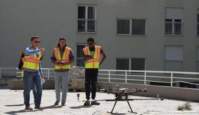
Undergraduate Jonathan Hale, a senior in the Unmanned Aircraft Systems Science program, was among the two-dozen students who worked with the S1000 octocopter in Kosovo. In particular, in his role as a “visual observer,” Hale’s job was to keep his eyes on the drone at all times.
“Any urban UAS operation is extremely difficult due to the amount of traffic, potential risk to bystanders, and the need to plan for the unexpected,” he explained. “With a large team in Kosovo, we were able to get a lot of roles covered. A few people were preventing pedestrians from walking anywhere near the UAS, one person was manipulating the controls, a few individuals were documenting the event via camera, and several others were visually observing.”
Before the Kosovo project began, Swinford tricked out the octocopter with appropriate technology. He evaluated available off-the-shelf sensors, selected the best options, and developed computer coding to make the whole system work in a smooth, integrated fashion. FT Technologies contributed two lightweight wind sensors, or anemometers that detect wind speeds based on changes in a sonic signal. A Pixhawk flight controller recorded GPS locations as well as the movement of the UAS. Sensor data flowed through an Arduino Mega microcontroller that served as the drone’s brain, making it possible to calculate wind speeds in three dimensions.
“Kosovo was the first demonstration of this platform for an urban UAS study,” Swinford said. “It’s versatile technology in terms of where it can fly. Going forward, it could be very useful for answering many different questions about meteorological conditions.”